Wednesday, October 10, 2012

Interview with PCT Thru-Hiker Anne Tully


Anne is a 2008 Appalachian Trail thru-hiker who said she’d never hike another long trail after completing the A.T. Two weeks later, she thought she might want to hike the A.T. again, but then didn’t give it much more thought. 

Four years later the urge to hike another long trail hit her hard. She started planning for the PCT at the end of 2011, and she and I met in March 2012 to talk about the similarities and differences of her experience on the A.T. and what she could expect on the PCT.

We talked again last Saturday, and I asked her about her experiences on the PCT and insights she gained on her 2012 PCT thru-hike.

When did you start at the Mexican border and when did you get to the end in Canada?
I started on April 20 and on September 4 I had made it to the border. I left through Manning Park on September 5.
Anne's trail name is Stride.
 I was talking to my aunt the other day, and realized, all of that is 2,700 miles.

What are your overall impressions of the PCT?
It’s interesting for me because I hiked a lot of it as a solo hiker. That’s a totally different experience than my A.T. hike where I had people with me. I walked at least 1/3 of the PCT alone and spent nights by myself. Northern California was the longest stretch where I was by myself.

When I look back at pictures I am taken back by how absolutely beautiful it was on the PCT. Moments I stopped in my tracks and was just literally in awe, but it didn’t make up for the fact that the trail was hard. When I talked to people before my hike, people told me I wouldn’t experience the physical pain of the trail because of the beauty. People romanticize the trail, in particular, the high Sierras. In fact, I think the Sierras were more difficult for me mentally; I became resentful because it was beautiful but it wasn’t enough to take the pain away.

At one point I was talking to [trail legend] Billy Goat, and he gave me the lesson I took away, to “take the trail for yourself.” Don’t allow other people to formulate your experience based on their experience.

There is stunning scenery, but you have to go in with the blank slate, without expectation, because it will likely be more difficult. If you go in with a romanticized vision you could be disappointed.

What was the best part of the hike?
Goat Rocks wilderness in Washington State is for sure a section that has stuck with me. When we went through the weather was perfect, the wildflowers, the lupine, were in full bloom. One fella I met had lived in the area for 57 years said he’d never seen the lupine in full bloom like that, ever. We had beauty of wild flowers everywhere and jagged rocks. You could see Mt. St. Helens and Mt. Adams you just finished walking around. Then, BAM!, Mt. Rainier. It was spectacular. There was lots of ridge walking there, and I liked that. 

In Oregon I liked the Three Sisters and Mt. Jefferson, and in California, Muir Pass was my favorite. I was blown away. It was one of the first times I felt truly stunned with what I was able to experience and live in.

What was the hardest part of the hike?
After I left Ashland Oregon alone, I was by myself for next three and a half days. Physically I was so tired. I had been doing 30-mile days in northern California. There were hikers ahead of me and hikers behind me. I couldn’t go any faster than the 30, 32, and 35-mile days I was doing in Oregon. I couldn’t slow down for people behind me to catch up because I was on a deadline to finish so I could return to work on time. I was by myself, feeling mental weariness. I was just struggling to stay in the game. I was hard on myself too. I just wanted to quit.

When I got to Crater Lake I really wanted to stop, and ask some tourist to take me away.

It was a time of growth, because I realized that I didn’t have a guarantee to finish the trail. It doesn’t matter how tough you think you are.

What kept you motivated to continue?
When I got to Crater Lake, I got food, and picked up my mail, but my maps weren’t there. That was almost the straw that broke camel’s back.

At the same time, I got mail from friend of mine that had letters of encouragement from other people. I sat outside and read all the letters. I was truly humbled that people would write me letters, and words of encouragement. There were letters from people I didn’t know. Those letters were awesome.

After that I had to go to the hiker box at the store. While I was there I talked to this girl, Jenna, and told her I was having a hard time. She and I talked for 5 or 10 minutes while I finished packing my food. She came back 20 minutes later with words of encouragement, energy bars, and invited me to her campsite for dinner. I ended up spending the night at her campsite.

It’s those kinds of interpersonal relationships with people, either in letters, or dinner with Jenna that kept me going. It was a rich experience to share life with people I wouldn’t have otherwise met. It was a beautiful experience that just connected for me, and gave me a morale boost.

What advice would you offer someone planning or starting a PCT thru-hike?
Try to touch base with as many people as you can who have hiked the trail to learn about their experience, but recognize that the weather is so variable. I talked to you, and you had a lot of snow. I didn’t have much snow but I had a ton of wind. A ton of wind. It was scary.

Be flexible in your mind. Maintain inquisitiveness the whole way. Ask people you meet along the way questions. I learned that people on the trail are very creative with their gear.

Lastly, be aware that there’s an obsession with ultra light hiking gear on the PCT. I probably, realistically, had forty people say, “wow, your pack looks heavy.” Even into Washington where I had walked 2,400 miles, they were still amazed. Ultra light isn’t for everybody.

I had a man challenge me about my tent, then lecture me about the number of ounces over 3 pounds. Ounces aren’t going to make or break my hike for me. That’s not important to me, but it was really important to him.

I encourage people to research it, learn from people, keep some perspective, and be confident in what you decide works for you. Be ready to pop off sassy comments; because people don’t get off the ultra light soapbox, I had to have my own.

The Northern California blues actually happened. It took me three months and week to walk California, two weeks for Oregon, and three weeks for Washington.

What did you do to prepare for the trail?
I felt really overwhelmed. I had a back injury the year I decided to do this. I had a strong conviction about hiking, so I took a slow, patient approach to physical activity until my back healed up. I did some running, and I did three day-hikes up to Wesser and back with food in my pack. I didn’t do much training.

From my Appalachian Trail experience I knew that if you are slow from the beginning, the trail will kick your tail into gear as it needs to be. Nothing prepares you for the trail except the trail. If I took it slow and mindful in the beginning my body would acclimate.

It takes realizing that the first couple of weeks does feel like work and is hard.

I had to be sensitive to the transition from normal life to trail life by understanding that I may feel overwhelmed at moments, because of the east coast to west coast culture change, by going alone, walking through the desert, and the elevation of the Sierras.

I had to start by learning about the first part of the trail, and then take the rest of it as it comes after that.

It’s cool when it moves from a feeling of working, to a feeling of a lifestyle. Eventually at some point you wake up robotically, pack up and start moving. You embrace it and enjoy it.

The same thing happened on the Appalachian Trail, where I felt like I can do this forever.
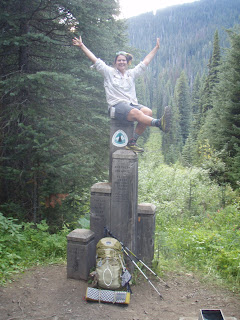
Thursday, October 4, 2012

Name change

I just changed the name of the blog from "Shadow of the Moon" to Leanna Joyner.

May's Super Moon viewed from the Blue Ridge Parkway.
Shadow of the Moon referenced my trail name "Moonshadow" that has been my alter-identity on long-distance trails, the Appalachian Trail and Pacific Crest Trail, and in trail circles for nearly ten years.

Maybe one day I'll write about how I got my trail name, how it stuck, and my general thoughts on trail names as part of the hiking subculture, but for now, suffice to say that this blog is an outward expression of myself in this world, as so it will be named.

There's another reason, too. When I started this blog I wasn't sure what my presence would be online. I was wary of identity theft, unsure of my posting frequency, or if anyone but friends and family would read it. I'm moving beyond the anonymity I one sought here to claim the voice and opinions that I share.

Thanks for sticking with me along this journey. I'm having a lot of fun with it so far and hope to bring you much, much more.

Wednesday, October 3, 2012

Be, Don't Do

Sometimes the things I need most seem counter-intuitive to what I think I need to do.


See, pressure around here has been mounting. I've been adding more projects to my plate, and they're all things I really enjoy doing. I've been giving presentations, writing for various publications, attending trainings, and organizing Joyus Groove classes. I've been settling in to a relationship with Marcus that's feeling good and solid and true; albeit, just like any relationship, it requires time, attention, and nurturing.

Meanwhile, he's been finishing his patio and putting finishing touches on his tiny house. For a while we were really stressed, spiraling in a place of new busy-ness as we simultaneously juggled our own worries and responsibilities.

It's in those times, with activities seemingly closing in around me like a tight corset, making it hard to breath, when it's hardest to find the latch and step outside. 

The singular salve that makes everything better, hiking. It's just there...outside the door, with a map, a bottle of water, an apple, a jacket, my headlamp (in case it turns dark), and my boots.

Marcus and I finally did just that on Sunday, barely speaking to one another for listening to the wisdom of the experience, Mother Nature, and our quieting minds.


When I get filled up with what I think I need to do, hiking helps me remember how to be who I am, and that, for me, is its greatest lesson.  


We drove to Camp Creek Bald and hiked to Firescald Knob along the Appalachian Trail. I think we'll return again this Saturday to hike a loop from the river up to the ridge, exploring more of Shelton Laurel, an area I've talked a lot about in my presentations lately.

Friday, September 28, 2012

Take a Tiny House Tour


I'd write something about this, but I've spent too many hours learning everything I needed to know to edit the audio and make a video. I hope you enjoy it. I find this to be a super fascinating project. We talk about Marcus' inspiration, original design, construction process, and costs.


If you can't view the embedded video, you'll find it here on YouTube. 

SmallerHouseLargerLife.com is under construction. If you'd like to contact Marcus Barksdale, reach him at smallerhouselargerlife@gmail.com.

This is my first audio and video editing project, ever. Please excuse all its imperfections. I blog about this and other things that interest me right here and as often as possible.

Thursday, September 27, 2012

I've Got a Book!

I've been kind of low key (okay, almost silent) about the fact that I researched and wrote a book with the working title Hiking Through History for the Appalachian Trail Conservancy. It's time I open up.

The fact is, I was waiting for the big "reveal." I was waiting for the book to materialize from its long metamorphosis from digital manuscript to bound form to validate me, as a historian, writer, author. I was waiting to ask for your support once it came out, to invite me to speak, purchase my book, and spread the word.

But I'm really excited for it, and I want to make it a reality, soon (as in edits finalized, layout complete, printed, and in your hands).  

I just made my third presentation on the book. I've presented at UNCA-Asheville, the Madison County Geneological Society, and, tonight, the Franklin Library. I'm honing my presentation, and I'm owning the fact that I've written a book. I'm amped! I got home two hours ago, and I'm still running off the excitement of sharing the the Appalachian Trail and the history I discovered. 

So, let's do this, shall we?

If you are interested or may ever be interested in my book, sign up with your interest here so I can demonstrate interest and support. Together: you, me, the Appalachian Trail Conservancy, we'll make this a reality.

Thanks,
Leanna


Monday, September 24, 2012

Resupply: The Appalachian Trail v. The Pacific Crest Trail

The Appalachian Trail Versus the Pacific Crest Trail: How to Pick Your Pleasure, Part Four

They weren’t designated the first National Scenic Trails for nothing. These two premier hiking trails are designed specifically to impart the beauty of their landscapes (seriously, trail builders think of these things).

Both are excellent choices, so whether you’ve finished hiking one of them and are ready to take on the next, or are simply deciding which one to hike for your first-ever thru-hike, here are some discernable differences that make each unique.

Town Stops & Resupply: While this won’t make or break a decision to hike one of these trails over the other, resupply is an important component of a long-distance hike, and these two trails are really different when it comes to resupply.  

A hitch in Maine
The A.T. has resupply points in high frequency, and they are generally only a short distance from the trail, which means hikers can carry less food and stop more regularly to resupply. Communities near the A.T. often have a pretty good awareness of hikers, and they’re fairly willing to pick up hitchhikers coming in to town, or returning to trail. Trail towns do a pretty good job of stocking what hikers need, and there are hostels and hotels that cater to hikers, offering discount rates for overnight stays.
The long wait. The hitch into Mojave finally ended with a ride in the police car. Thankfully the patrolman looks out for hikers in need of a ride so they don't become casualties of the intense roadside heat.
The PCT doesn’t have quite the same level of awareness among drivers, and the towns are further from the Trail, which means longer waits while hitchhiking and longer rides once someone picks you up. The bigger resupply stops do carry standard fare for hikers’ diets, but there are a lot of smaller stops where you may still need to rely on a mail drop.
I got a hitch with these nice fellas near Wrightwood, CA.

Even if hiking solo, hitchhiking to towns in pairs is the safest approach. I take this precaution seriously as a female hiker. While it’s not always possible to hitchhike with others, the fact that more people hike the A.T. means that there are generally other hikers around when you get ready to hitch to town, or back to the trail. In all cases, use your gut. If someone seems odd, by all means, find a reason to get out of taking them up on their offer for a ride ("Oh, I just remembered that I think I left my camera back at my last stop on the Trail...Gotta get it. Thanks anyway!")

Trail Guides: When planning and hiking, here are my recommendations on the best resources for each of these trails. I would use them in these combinations.

Pacific Crest Trail 
Water report (I'm not sure about the future of this site as the person who compiled the information passed away in August. Hopefully another PCT enthusiast will undertake the effort in his absence.)

Appalachian Trail


This is the final installment of a four part series on the differences between these 2 trails:
Part One: People
Part Two: Elements
Part Three: Trail terrain, views, snow
Part Four: Resupply

Do you have experience with both of these trails? What do you think are the biggest differences? 

Saturday, September 22, 2012

True or False: the A.T. is hard; the PCT is easy

The Appalachian Trail v. the Pacific Crest Trail: How to Pick Your Pleasure, part three

They weren’t designated the first National Scenic Trails for nothing. These two premier hiking trails are designed specifically to impart the beauty of their landscapes (seriously, trail builders think of these things).

Both are excellent choices, so whether you’ve finished hiking one of them and are ready to take on the next, or are simply deciding which one to hike for your first-ever thru-hike, here is one of several discernible differences that make each unique.

The Trail: I’m talking treadway or footpath here. Every A.T. hiker hears that PCT is so much easier to hike. Every PCT hiker hears that the A.T. is like walking through a green tunnel. So, let’s get all this out in the open.
Gradually graded Pacific Crest Trail in Southern California

The A.T. is hard. The PCT is easy. These generalizations, like most, don’t tell the whole story. The Pacific Crest Trail is primarily more gently graded than the A.T., and this difference is most starkly apparent at the outset of a northbound thru-hike, whether you start at Campo, California, or Spring Mountain, Georgia. While most hikers intend to train for their hike (and some do) most set out on a trail having scrambled to organize the rest of their lives so they can leave to fulfill their dream, often starting out with good intentions but not a lot of strength in their “hiking legs.” Plus, it’s my opinion that there’s no better training for a thru-hike than a thru-hike, but that’s another post entirely.

The difference at these trails’ southern terminuses means you may be able to easily hike 15 to 20 miles on day one in California, where you may only be able to hike 6 or 8 in Georgia. The difference is elevation change and the grade of the trail, but to generalize and say all of the PCT is easier would be going too far and excludes other factors of a PCT hike.

The fact is the PCT through the Sierras is difficult, given the altitude, terrain, river crossings, and snow; it’s not always a cakewalk. In the same token, the A.T. isn’t always a steep ascent and steep descent; there are rolling meadows, riverside ambles, and ridgeline walks. They both have their unique challenges, so let’s not get crazy with generalizations.

Sure, you can hike longer mile days on the PCT with a bit less fatigue, but you also need to cover 400 more miles on that trail in a slightly shorter window of time than on the A.T. (2,180 on the A.T. vs. 2,600 on the PCT).

Green Tunnel v. Views for Miles: I like to think of the Appalachian Trail as an experience in minutia, all the small wonders that make up this grand spectacle of nature; this includes walking through fog-shrouded tunnels of rhododendron grown so tightly together that I feel like I’m walking through a fairy tale. There are amazing views to be had along the A.T. from rock outcroppings and mountain summits, but they are the special features of the Trail, not necessarily a daily requirement. If they were on the food pyramid, amazing views would be the decadent dessert that you get in moderation, while walking in the rest of the experience provides well-balanced nourishment.
See the whit blaze on the rock in the center? Yes, this is the
Appalachian Trail in Pennsylvania. (I love to dispel the
generalization that ALL of Penn. is like this though.)

The PCT offers views for miles around. In fact from where you walk, you can often see the trail ahead snaking off into the distance. This has the potential to inspire as well as discourage you, especially if you are tired and know your destination is far beyond sight. From every place you stand, you can take ten amazing photographs, easily. The key in such an environment is to find awe in the landscape that is perpetually on display.

Because you can become desensitized to either the vast beauty laid out before you on the PCT, or the forest’s secret wonders and “special features” on the A.T., it’s best to steer clear of comparing the apples and oranges in this regard, and just accept them as designed.

Snow: As a Southerner the snow took me by surprise on the A.T. and the PCT, at different times and in different ways. Here’s how:

On the Appalachian Trail, assuming a start date before April, you will likely get snow. While other areas of the Southeast may see not one white flake, A.T. hikers will get a dusting, if not a dump, because of the elevation and the likelihood for the mountain tops to “catch” and stall the weather system. Hikers starting in February or March often get snow in Georgia, North Carolina, and Tennessee, most notably in the Great Smoky Mountains National Park. These spring snows are wet and heavy, and can come unexpectedly (like following several days of spring sunshine). Like any other time on the A.T. it’s important for hikers be aware of their condition and follow tips for preventing hypothermia.
I awoke to this snowfall the morning I walked into North Carolina.
On the PCT, you will encounter snow. It’s a matter of when and where. The thing I was least prepared for and learned the most about was snow and snow traversing, because I was traveling across som near vertical snowfields. The terrain that offers views for miles is the same terrain that means there are no big trees to cling to should you slide down an icy slope . A slip without knowledge of self-arrest techniques could have been deadly. As it was, I was uneasy and less than surefooted on that terrain. While snow conditions differ from year to year, when I hiked there was a lot; I must have walked three miles through snow to reach Muir Hut and another five or six in snow after the summit celebration.
On the PCT
If I had to do it all over again I would have taken some mountaineering courses on snow and snow travel before my hike (and when I do it all over again, I will).


My trepidation for traveling in snow without my ice axe (I needed it much sooner than I thought and had sent it much farther ahead), led me to make a penny wise, pound foolish mistake. My friend Morph and I skipped around snowy San Jacinto and Fuller Ridge to a section farther north because I didn't have an ice axe. I should have bought one at the outfitter and kept hiking. As it was we spent excessive time and money hiking a more northern section, then returned later to re-capture this missing section of the Trail.


This is part three of a four part series on the differences between these 2 trails:
Part One: People
Part Two: Elements
Part Three: Trail terrain, views, snow
Part Four: Resupply